The HDTomoGPR was developed on a DOE Phase II STTR entitled “Ground Penetrating Radar System (GPR) and Algorithms for Fine Root Analysis” from the DOE (Department of Energy). GPR technology is a superlative choice for non-destructive imaging and analysis of roots. Current GPR-based root analysis techniques are designed for coarse root analysis and are unable to provide an accurate image of the root structure. The focus of this project is to develop an unconventional GPR system designed with greater accuracy, penetration depth, and imaging capabilities will extend the GPR technology for more accurate root analysis.
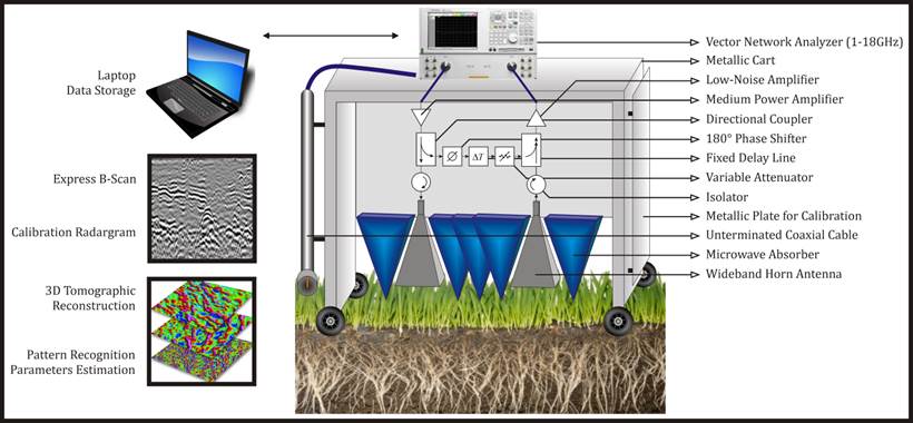
In order to extend the GPR technology to fine root analysis, it is necessary to design an unconventional GPR system that provides root information in the entire area under observation with greater accuracy and penetration depth. The GPR root analysis system begin developed provides the accuracy and penetration depth necessary for accurate root analysis by using a novel variable frequency GPR design. The system consists of a field deployable GPR platform, and an advanced 3D reconstruction and processing suite. The platform consists of multi-frequency radar mounted on a precision controlled scanning platform. The scanning platform allows for increased signal-to-noise, unmatched visualization support capabilities (through 3D tomography using multiple look angles and polarities), and repeatable measurements. The features and capabilities of the system include 1) innovative direct-path interference mitigation and soil property estimation, 2) novel first break mitigation, 3) real-time visualization to quickly inform the operator about the conditions of the soil, 4) state-of-the-art tomographic reconstruction and post processing to provide the user with detailed 3D image reconstructions, root distribution information, and statistical analysis.
The resulting GPR root analysis system can be easily deployed by non-specialists without any radar background or expertise. As such, biologists, horticulturists, and life scientists will benefit from the successful commercialization of this technology for a variety of scientific studies and assessments. The GPR system can also be used as a planning tool prior to development of an area. In addition, the tomographic GPR system can be modified for other environments where it is desirable to survey small structures in real-world soil environments, e.g., DOD applications.